In the next few days we will follow the Panj River upstream and gain more and more altitude until we reach the high plateau of the Pamirs. Following the Panj River also means we will also follow the Afghan border. Today, we cycled the first 90 km and gained in total 400 m of altitude.
Cycling through narrow gorges
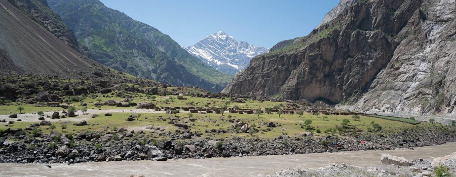
In the village where we spent last night, the valley floor was quite wide, but soon after starting to cycle, we entered a truly impressive gorge with high rock faces, with dimension I have not seen before. On a length of roughly 30 km the rock walls were going up very steeply for up to around 3000 m on both sides. The valley floor was sometimes only a hundred meters wide, from which the Panj River took up most of the space. The two roads, one on the Tajik side and one on the Afghan side of the river, were squeezed between these rock faces and the river and it was stunning to cycle through this narrow canyons, even though I was a bit nervous passing under such high rock faces, because there is always a danger of rocks falling down and the road was at some places covered with holes from falling rocks. And at one place, the whole road was torn down by a landslide, but there was already a workaround in place through lose rocks.
The Panj River itself was also very impressive. Now in spring it is basically carrying all the melting water of a large part of the Pamirs. Because of all the sediments that get washed down, the water was colored in a deep brown. There were violent rapids where the water was splashing up several meters when flowing over rocks inside the river. I am no river rafting expert, but I would never attempt to go down this river in a small boat, despite the awesome scenery.
After 30 km, the valley got a bit wider again, but not less impressive, as we could spot then better the high snowy peaks of the Hindu Kush on the Afghan side.


Life inside the gorge
There is not much space for life in these narrow canyons, but every few kilometers there was a small stretch of land either on the Afghan or the Tajik side not taken by the river. This land was then used for agriculture and small villages. Especially on the Afghan side, sometimes the houses were even built onto rocks leaving more space for agriculture. And where the slopes of the mountains were a bit less steep, there was also agriculture up the mountain flanks. They really optimize every usable square meter here in the valley in order to survive.
The political situation along the Afghan border
When I tell family members or friends that I am cycling along the Afghan borders, they usually get worried about it. But during the first two days, apart from the increased military presence on the Tajik side, everything was quite unspectacular. We passed quite a few Afghan villages with sometimes only a few hundred meters distance. The Afghan people on the other side were equally happy to see us as on the Tajik side waving their hands, children were playing outside, animals were roaming around. No sign of war at all. Sometimes it is a pity not being able to actually visit these small villages because I am sure the Afghan hospitality would be similar to the one we experience on our side of the river.
Staying overnight in Yoged
After 90 km impressive kilometers, we decided to stay at a homestay in Yoged, another small village along the river. Tomorrow we will continue the valley and collect more impressions of this wonderful area.
Detailed Track
Max elevation: 1212 m
Min elevation: 807 m
Total climbing: 2321 m
Total descent: -2043 m
Total time: 10:35:06


